
What is a Parcel ID?
A Parcel ID (PerceelsID) is the unique identification number of a parcel, comparable to the ID number of a person. The number consists of two letters and two groups of four digits, for example BG-6200-8568. The letters refer to the district area (BG stands for Blauwgrond), the digits are linked to the geographic location of the parcel.
Its introduction is regulated in the Parcel Identification Decree (Besluit Perceelsidentificaties). The aim is that eventually all parcels in Suriname have a Parcel ID. MI-GLIS (Management Institute for Land Registration and Land Information System) assigns the numbers.
You may also see "Perceels-ID" or "perceel ID". They all mean the same identification.
Why is a Parcel ID important?
- One clear number: your parcel is unambiguously identified and registered.
- A verified map: a surveyor surveys your parcel and prepares a survey plan (uitmetingskaart) showing location, shape, surface area and coordinates. MI-GLIS checks that plan according to the applicable procedures.
- Your map is in the MI-GLIS archive: if you lose your map, you can ask them for a duplicate.
- Easy to find again: with the coordinates you can locate your parcel using GPS or a suitable smartphone app.
When do you need a Parcel ID?
For a number of legal acts a Parcel ID may be mandatory, for example when:
- selling a parcel
- donating a parcel, for example to a family member
- establishing a mortgage on a parcel
- a public sale or auction
- an attachment (seizure)
- dividing or subdividing a parcel (read more about the subdivision permit)
- merging several parcels
- accepting a declaration of readiness (bereidverklaring) from the government, if a Parcel ID is required for it
The requirements differ per legal act. So check in good time whether your parcel needs a Parcel ID. In doubt? Contact us and we will think along with you.
Applying for a Parcel ID in 5 steps
Fill in the online form.
You enter your details, the district and the surface area of your parcel and upload the requested documents.
See the estimated cost.
As soon as the district and surface area are filled in, the form immediately shows the estimated cost.
Submit your request.
You immediately receive your request number and the invoice. Keep the request number safe.
We process your request.
We survey your parcel, prepare the survey plan and submit the application to MI-GLIS.
Follow your request online.
With your request number and surname you can see the progress on Track your request.
Why online with Major One?
- You enter your details whenever it suits you.
- You see the estimated cost before you submit.
- You immediately receive a request number and an invoice.
- You follow the progress online, without having to call.
Please note: the application to MI-GLIS must be submitted by a sworn land surveyor. Major One works under the supervision of the sworn land surveyor, Mr. Giovanni Winter.
What you need to get started
You upload these when you submit your request (pdf, jpg or png, maximum 5 MB per file):
- Relevant map
- Mortgage extract (hypothecair uittreksel) / Deed of transfer / Approval decision
A complete file prevents unnecessary delay.
What does a Parcel ID cost?
The costs consist of surveying your parcel, preparing the survey plan and the approval of the plan, including the allocation of the Parcel ID by MI-GLIS. The price depends on the district and surface area of your parcel.
| Surface area | Paramaribo and Wanica | Commewijne, Para and Saramacca | Coronie, Marowijne and Nickerie |
|---|---|---|---|
| up to 1,000 m² | SRD 7,800 | SRD 9,800 | SRD 17,800 |
| up to 1 ha | SRD 13,800 | SRD 16,150 | SRD 24,800 |
| up to 3 ha | SRD 19,500 | SRD 26,500 | SRD 29,500 |
| up to 7 ha | SRD 23,500 | SRD 31,170 | SRD 34,500 |
| up to 10 ha | SRD 27,500 | SRD 36,000 | SRD 50,000 |
Parcels smaller than 200 m², parcels larger than 10 ha and parcels in Brokopondo and Sipaliwini are quoted on request.
Is your parcel not in the table? Then we prepare a quote. You also see the estimated cost in the request form.
How long does a Parcel ID application take?
After you have submitted your request and all documents have been provided, MI-GLIS takes the application into processing for verification within one week under the usual procedure. The official completion then takes about 4 to 6 weeks. The total lead time depends on how complete and correct your details are and on the processing by MI-GLIS.
Our advice: fill in all details correctly and provide your documents in good time. The terms mentioned are indicative.
What does a Parcel ID look like?
A Parcel ID consists of two letters and two groups of four digits. The letters refer to the district area, the digits to the geographic location. In the example BG-6200-8568, BG refers to the district area Blauwgrond.
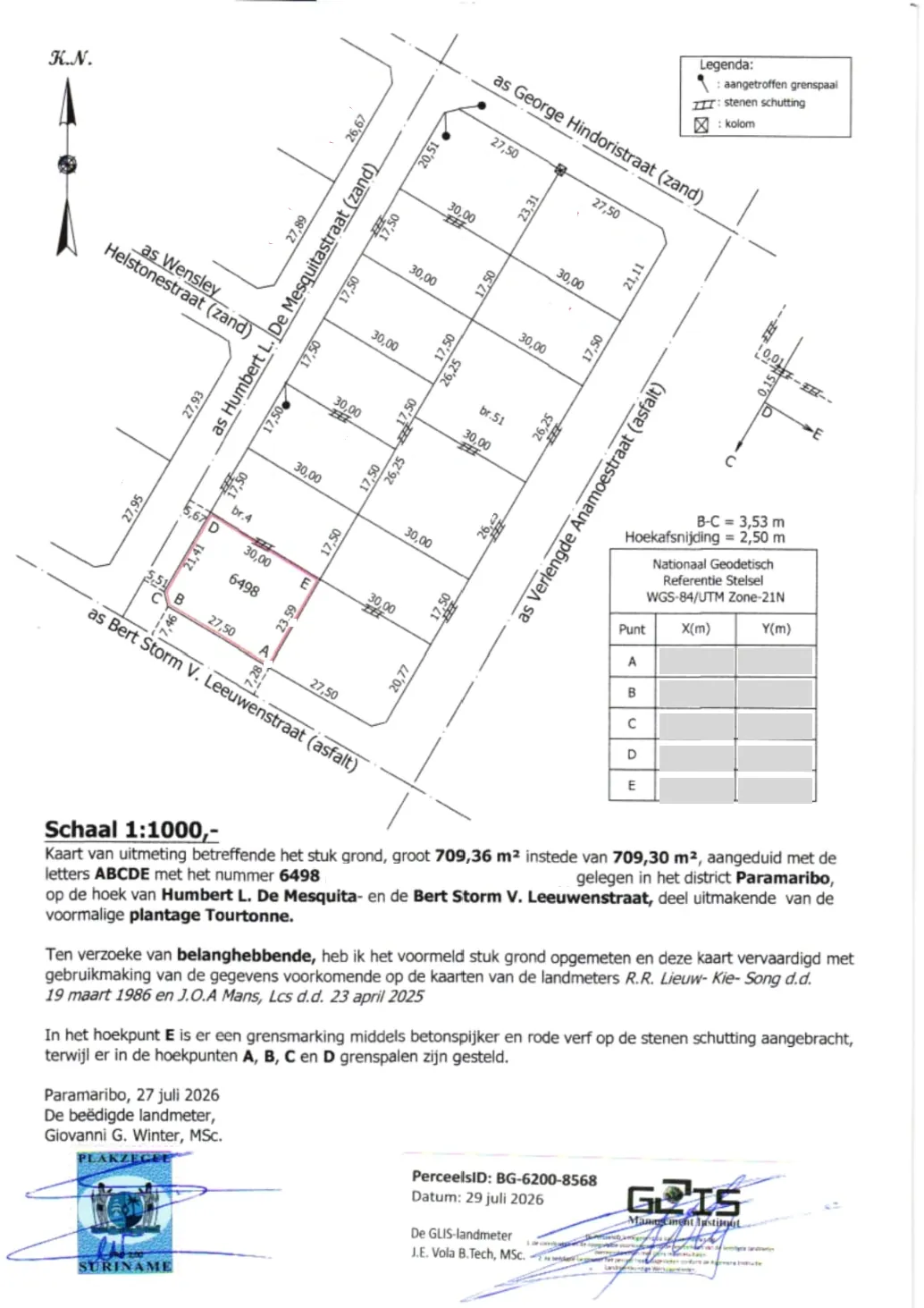
How to read the map
- The Parcel ID: bottom right, with the date and the stamp and signature of MI-GLIS. In this example it is BG-6200-8568.
- The parcel: outlined in red, with the corner points A to E and the dimensions of each side.
- The coordinates: the table on the right gives the X and Y value of each corner point in the National Geodetic Reference System (WGS-84, UTM zone 21N).
- Scale and surface area: below the map are the scale, the surface area and the location of the parcel in words.
- The surveyor: bottom left are the signature and the stamp of the sworn land surveyor.
Frequently asked questions about the Parcel ID
Is a Parcel ID mandatory if I want to sell my parcel?
Often it is. A Parcel ID may be required for a sale, donation, mortgage, auction or attachment. The requirements differ per legal act, so check in good time. In doubt, contact us.
What is the difference between a survey plan and a Parcel ID?
The survey plan (uitmetingskaart) shows the location, shape, surface area and coordinates of your parcel and is prepared by a surveyor. The Parcel ID is the unique number that MI-GLIS assigns after the plan has been approved.
Is it mandatory to have the parcel surveyed again before applying for a Parcel ID?
Yes. Applying for a Parcel ID at MI-GLIS requires a physical field survey. The parcel must be surveyed again in accordance with the standards and requirements laid down in the Parcel Identification Decree (Besluit Perceelsidentificaties) of 4 October 2016, the Land Surveyors Instruction (Landmetersinstructies) of 15 October 2014 and the GLIS Act (GLIS-wet) of 25 September 2009.
What is the difference between PerceelsID, Perceels-ID and perceel ID?
There is no difference. They all refer to the same identification of a parcel. We write PerceelsID.
Who may apply for a Parcel ID?
The application to MI-GLIS must be submitted by a sworn land surveyor. So always check that the surveyor handling your application is authorised to do so. Major One works under the supervision of the sworn land surveyor, Mr. Giovanni Winter.
What does a Parcel ID cost?
That depends on the district and surface area of your parcel. In the request form you see the estimated cost as soon as you enter the district and surface area. See also the rate table on this page.
Which documents do I need to apply for a Parcel ID?
They are listed under "What you need to get started" on this page. You upload the documents in the request form.
How long does it take before I have my Parcel ID?
Under the usual procedure MI-GLIS takes the application into processing within a week and then completes it in about 4 to 6 weeks. These are indicative terms that depend on how complete your details are.
I have lost my survey plan. What now?
Survey plans with a Parcel ID are kept in the MI-GLIS archive. Ask them about the possibility of a duplicate.
How do I follow my request?
After submitting you receive a request number. With it and your surname you can see on the Track your request page how far your request is.
Contact and opening hours
- Address: Samuel Kafiludistraat 42, Paramaribo
- Phone: 400-564 / 845-1623 / 875-1514
- E-mail: contact@majoronesurveying.com
- Opening hours: 08:00 to 16:00
Official information about the Parcel ID and the procedure is available from MI-GLIS. Major One guides you with the application and the surveying work.
Last updated: October 2026